Historical Resources
Unlike other online repositories, Virtual Vinegar Hill also allows the site user to see multiple types of information at the same time. Visitors who are interested in specific individuals will be able to view personal, financial, and visual data options on an easy to navigate screen. Furthermore, maps of Vinegar Hill allow visitors to place their subjects in the virtual representation of the physical space. The following list points to the resources on this website.
Oral Records
Researchers have gathered dozens of interviews with past and present Vinegar Hill residents. Transcripts as well as video records have been digitized so that site visitors might, through the words of those who experienced the community’s changes, catch a glimpse of life in Vinegar Hill.
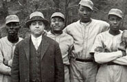
Photographs
Hundreds of contemporary photographs of Vinegar Hill have also been collected from both public and private sources. These prints present the physical environment of individual homes, local streets, stores, and other areas in Charlottesville.
Government Reports
With these government surveys and appraisal documents, visitors to Virtual Vinegar Hill are presented with a broad overview of the area. Surveys demarcate the economic fault lines of Charlottesville. Site users can delineate between affluent and less developed sections. Giving a geographic sense of the Vinegar Hill area, the records also present a stark picture of economic inequality in the mid-twentieth century.
Deeds and Property Sales Histories
This resource allows site visitors a look at financial (property) transactions of a dynamic neighborhood. The records highlight constant movement from inside and outside the Vinegar Hill community in the years before its demise.
Blueprints
Virtual Vinegar Hill boasts a large number of blueprints of residential buildings. These schematics, when compared with photographic evidence, allows visitors to reconstruct and better visualize the living conditions of Vinegar Hill families.
Maps, GIS Maps
Combining contemporary maps of Charlottesville and the Vinegar Hill neighborhood with data from land deeds, business records, and photographs, this feature allows visitors a bird’s-eye view of the city and community. This can help pinpoint individual homes as well as inform viewers of the demographic movement and development of the area.
Taken as a whole, this resource-rich database allows historians, teachers, and visitors to construct, through substantial public and private records, the vitality of Vinegar Hill’s familial, business, economic, and political life.