

University of Georgia: Hargrett Rare Book Library's Rare Map Collection
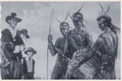
Description: This resource is a seventeenth-century map of North, Central, and South America surrounded by a border of detailed drawings depicting the native inhabitants of the Americas, and many of the impressive towns and geographic features of the landscape which Europeans saw in the course of their explorations. The map can be used as a starting point for student discussion of the ways in which Europeans were fascinated by the "New World" scenery and its native inhabitants. It's also interesting to point out to students how the native peoples portrayed in the drawings are stylized as "noble savages."
Teaching Tips:
"Do Now" Suggestions
- If students have already worked with the other Hargrett map (Virginia parties australis, 1633), they could begin by creating a Venn Diagram comparing and contrasting the two Hargrett maps.
- With a copy of the map at their desks or displayed on the overhead projector, or, best, on their computer screen-- students could respond in their journals to the question, "What can you conclude about what the map-maker thought was important about North and South America, from this illustrated map?"
- Groups of students could analyze different features of this map: for example, the features included in North America, the features included in South America, or the depiction of Native Americans. Their analysis could include inferences as to the artist's perspective on the particular feature, supported by actual inclusions (and exclusions) from the map. Each group could then share their conclusions with the class.