
University of Georgia: Hargrett Rare Book Library's Rare Map Collection
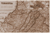
Description: This resource is a beautifully executed, highly detailed image of a very early map of Virginia and the Atlantic Coast. With this map, students can verify both the extent and the limit of European knowledge of native peoples and geographic features of the tidewater area - an area to which Europeans were confined by the presence of powerful coastal and interior tribes. It is also interesting to point out to students the conjunction of the Latin style typically used by European mapmakers of that period, with the native American names for peoples and features of the landscape. Students using this resource might also benefit from having access to a print atlas including images of Virginia and the Atlantic coast.
Teaching Tips:
"Do Now" Suggestion
- Students could create a map of their home (or school) neighborhood, then discuss what symbols and features should be included on the map. After completing this exercise students could begin an analysis of the map presented here.
- After a teacher-led discussion of some of the features of this map, students could create Venn Diagrams, comparing and contrasting characteristics of this map with a modern-day map of eastern Virginia and/or the United States' Atlantic coast.